Out here on the edge of the continent, the dynamics of nature are on full display. Surrounded by water and fully exposed to the weather, the Outer Banks is just one of those places where you can easily witness a constant show of the world and all its wonders.
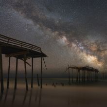
Consider the fascinating sky above us. Thanks to the dark skies of undeveloped Cape Hatteras National Seashore, the Outer Banks is one of the best places on the East Coast to clearly see the Milky Way, planets, constellations, meteors and comets.
The ground beneath us, the barrier islands, are themselves a dynamic natural process. The landforms are simply sand deposits in the ocean, ever shifting as they respond to wind, waves, currents and tides. On land and under water, the sand is constantly moving. Shoals build and shift, inlets open and close, ocean and sound shorelines erode, causing houses to fall into the sea, and sandbars and islands build up, like Shelly Island did off Cape Hatteras in 2017, before slowly washing away again.
The waters around us are ever intriguing, the textures and hues – all shades of blue, green, brown, gray, silver and lavender – constantly changing due to wind, sunlight, clouds and time of day. The ebb and flow of the tides is less perceptible here than some places on the globe, but you know it has changed when your towel and beach toys are suddenly swallowed by a wave, the fish suddenly start biting or the barnacles on the piling docks are visible. Our islands are a marker of sea level rise, with aerial photographs clearly telling the story of climate change – here rising 3 to 4 mm per year, three times faster than the global average!
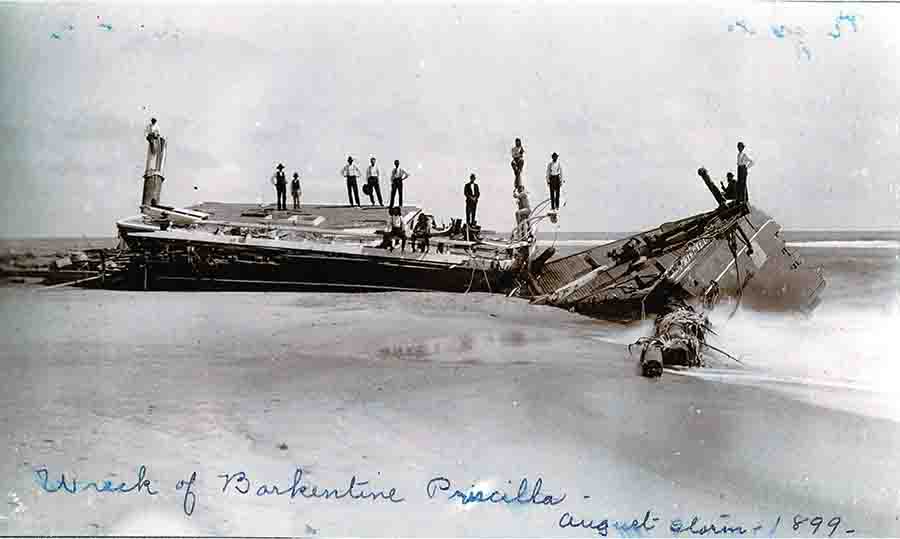
Photo: Wreck of the Barkentine Priscilla, Aug Storm 1899 - Carol Cronk Cole Collection
In the air around us, the ever-present salty winds affect our lives greatly. Blowing sand swallows trees and buildings, decimates dunes in some areas and builds them up in others. Live oaks slant in the direction of the prevailing winds, and salt-stunted cedars twist and turn in their struggle to thrive in the salty air. Swimmers know that winds from the east push in the warm waters from the Gulf Stream, surfers know that offshore winds make for better barrels, and shellhunters know to look for the ocean’s bounty of shells and tiny creatures after an onshore blow.
And the wildlife! Mama sea turtles leave highly visible evidence that they have emerged from the sea and laid their eggs in the sand. A few months later, the hatchlings crawl from that nest to the sea, leaving tiny flipper tracks behind. Migrating monarch butterflies stop here to breed and rest each autumn on their way to Mexico, and more than 400 species of birds spend all or part of their life on these islands. And that’s just the tip of the iceberg for the wildlife that is so easy to see here.
Needless to say, if you are one to take notice of nature’s beauty and processes, you’ll have more than a lifetime of entertainment on the Outer Banks. Kicking up glowing phosphorescent creatures in the surf’s edge at night, witnessing a blue crab shedding its shell, realizing the slow rusting of your bicycle spokes, discovering a new form of sea life washed from the ocean (who knew about sea pansies?!) – it’s all part of the mundane but nonetheless miraculous daily phenomena of life on a barrier island.
And then amidst the everyday natural processes are those that stand out for their sheer dramatic force — thunderstorms, nor’easters, waterspouts, tornadoes, tropical storms, hurricanes and wildfires. Frequent storms are a fact of life here, and some of them have been very destructive. They are a part of the natural world we do not always want to face, but they are the price of living so close to the edge.
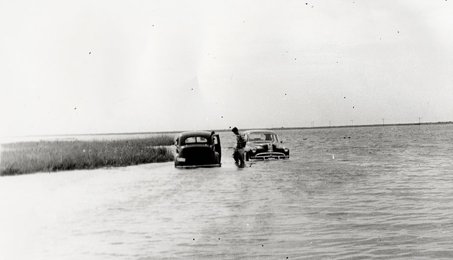
Photo: Cars in the ocean - David Stick Papers, OBHC
HURRICANES
Tropical storms and hurricanes are a fact of life along the East Coast. The East Coast experiences a high number of hurricanes because of the warm waters of the Gulf Stream, which acts as fuel for the storms, and because wind patterns drive them in this direction as they move westward from the tropics. Hurricane season, when the storms are most likely to strike, is from June 1 to November 30.
According to Jay Barnes in North Carolina’s Hurricane History, hurricanes were rarely given names prior to the 1950s. North Carolina and the Outer Banks were hit with several severe hurricanes in the 1800s and early 1900s. In the 1950s, eastern North Carolina earned the moniker “Hurricane Alley” after being hit by six hurricanes in seven years. In one particularly bad year, from October 1954 to September 1955, eastern North Carolina was struck by four destructive hurricanes: Hazel, Connie, Diane and Ione.
Here are just a few of the standout hurricanes the Outer Banks has experienced.
1846 This legendary storm reshaped the Outer Banks. In addition to wrecking homes and ships, the tremendous hurricane caused water to rush from ocean to sound, creating the inlet we now call Hatteras Inlet on the night of September 7. The next day, the storm caused the opening of what is now called Oregon Inlet.
1899 The San Ciriaco Hurricane charted a deadly path through the South and eventually hit Ocracoke and Hatteras islands extremely hard; homes were swept away, ships sank and Diamond Shoals lightship washed ashore. The Hatteras Weather Bureau’s anemometer was blown away, but some readings suggest this storm may have reached Category 5 intensity. The northern Outer Banks also saw flooding and damage in the storm. Seven vessels wrecked off the N.C. coast, and six were lost at sea without a trace. One of the most famous lifesaving missions on the Outer Banks, the wreck of the Priscilla, occurred during this storm when Rasmus Midgett of the Gull Shoal Life-Saving Station singlehandedly saved 10 lives.
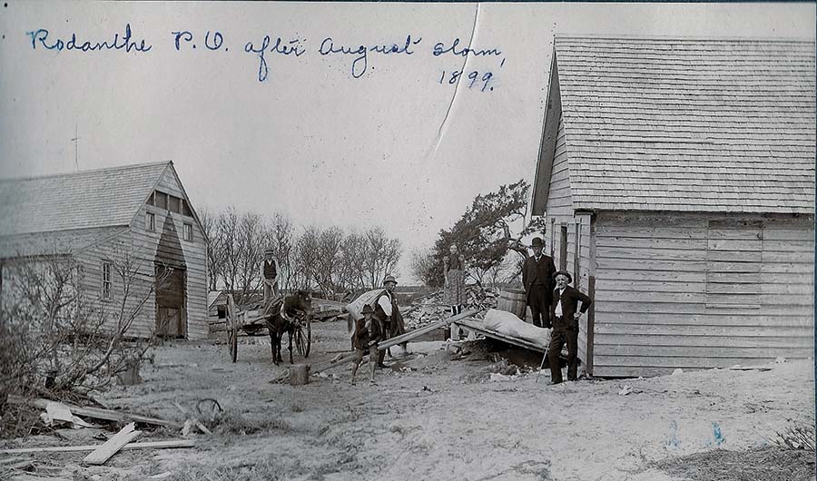
Photo: Rodanthe Post Office after August storm, 1899 - Carol Cronk Cole Collection, OBHC
1944 The Great Atlantic Hurricane, a Category 2, caused destruction from Cape Hatteras to Newfoundland. It stayed off the coast but caused significant damage. In Nags Head the storm sank two Coast Guard cutters that were protecting ships from German U-Boats in WWII. Hatteras Island experienced flooding, particularly in Avon. At the time, the Civilian Conservation Corps (CCC) was installing sand fences like formed sand walls along the beach. Massive storm surge from the sound spread across the island, but the sand walls blocked the water from flowing into the ocean, causing the water to pool in Avon. Ninety-six of the village's 115 homes were destroyed or washed off their foundations. In all, the storm claimed 344 lives total in its 900-mile path.
1960 Category 4 Donna destroyed Florida then set its sights on the N.C. coast. The worst of it was to the south, but Manteo and Nags Head experienced severe flooding and damage on the back side of the storm. Raging floods swept through Kitty Hawk, Kill Devil Hills, Nags Head and Manteo from the sound.
1985 Category 3 Hurricane Gloria made landfall in Hatteras, creating a 6- to 8-foot storm surge in many parts of Dare County. Highway 12 was overwashed in several locations. Downtown Manteo flooded with 4 feet of water.
1993 A major Category 3, Hurricane Emily remained offshore but caused record flooding on Hatteras Island, the worst in more than 30 years. Flooding along the shores of Pamlico Sound on the island was from 8 to 10 feet higher than normal. In all, about 700 buildings were damaged, and about 25 percent of the island’s residents were homeless. Cape Hatteras School was destroyed by flood waters. Six Coast Guard houses were destroyed by a tornado.
1999 First Hurricane Dennis hovered offshore, dropping up to 19 inches of rain on the Outer Banks. Less than two weeks later came Category 2 Hurricane Floyd. The combination of the two storms caused $10 million in damages due to flooding along the Outer Banks and extreme inland flooding. Statewide, there were 35 deaths, 7,000 lost homes and 56,000 damaged homes.
2003 Category 2 Hurricane Isabel wreaked havoc on the Outer Banks. Making landfall at Drum Inlet in Cape Hatteras National Seashore, the storm brought 104 mph winds and 6 to 10 feet of storm surge. The storm created a breach between Frisco and Hatteras village. The temporary inlet, known as Isabel Inlet, cut off power, water and vehicular access to Hatteras village. The storm created major ocean overwash and wiped out piers, highways, beaches and homes, causing $167 million in damages in Dare County.
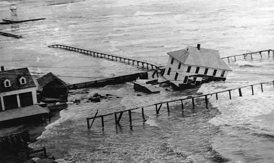
Photo: Coast Guard Station Destroyed by Hurricane - Aycock Brown Collection
2011 Hurricane Irene made landfall near Cape Lookout as a Category 1 downgraded from a Category 3. There was hope that downgrade was good news, but it was not to be. Irene caused catastrophic storm surge (10 to 12 feet) from the sound in Avon, Rodanthe, Waves and Salvo. This storm changed the landscape, creating two distinct inlets along Pea Island. Residents of the Tri Villages were unable to return home for 10 days, and Highway 12 was closed from August 27 to October 10. Hatteras residents had to ferry to the island from Stumpy Point to Rodanthe. The Captain Richard Etheridge Bridge on Pea Island was constructed at the site of the new inlet, dubbed Irene’s Inlet or New New Inlet among the locals.
2019 Category 1 Hurricane Dorian came ashore at Cape Hatteras, causing a 4- to 7-foot storm surge in Hatteras and damaging 1,126 homes from Duck to Hatteras. However, Ocracoke took the brunt of the storm. A 7.4-foot storm surge flooded Ocracoke’s homes, cars, streets and buildings. Thankfully there was no loss of life, but the storm took a major toll on tourism and the islanders’ way of life.
Much of the information for this section on hurricanes came from North Carolina’s Hurricane History by Jay Barnes.
NOTABLE NOR’EASTERS
Nor’easters are large storms that bring wind, rain and/or snow to the East Coast (typically Massachusetts to North Carolina), blowing in from the northeast direction. While not hurricanes, they can produce hurricane-force winds and extreme flooding and be just as destructive.
The Ash Wednesday Storm
The most infamous nor’easter to hit the Outer Banks was the Ash Wednesday Storm in March of 1962. This was by far one of the worst storms to hit the Outer Banks, and anyone who lived on the Outer Banks then has a dramatic story to tell. There’s a whole book about it, The Ash Wednesday Storm by David Stick, and a documentary about it, The Ash Wednesday Storm in Nags Head March 5-9, 1962.
This nor'easter is considered one of the 10 worst storms in 20th-century United States history. It pounded more than 500 miles of the East Coast for three days. Throughout six states it killed 40 people, injured more than 1,000 and caused hundreds of millions of dollars in property damage.
The northern Outer Banks was hit hard for 60 hours of fierce winds and raging surf, causing as much damage as severe hurricanes. The dune line was flattened from Nags Head to Virginia Beach, and a 200-foot wide inlet was opened near Cape Hatteras near Buxton (and later closed by the Army Corps of Engineers). Thousands of oceanfront homes were damaged or destroyed, and Nags Head took a particularly hard hit. What was difficult about this storm is that it was a surprise; no one got any warning that it was going to be as bad as it was.
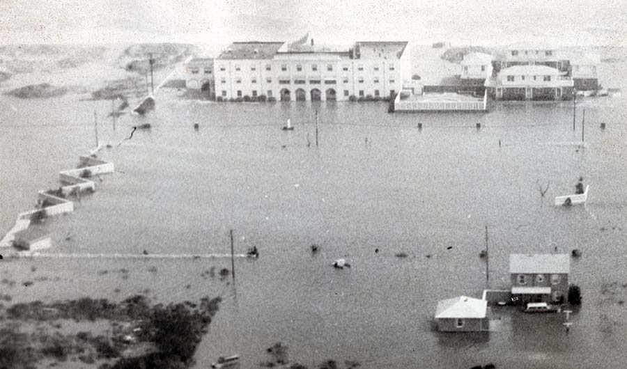
Photo: Carolinian Hotel after the Ash Wednesday Storm, March 1962 - DV Meekins Papers
FREEZES and SNOWSTORMS
The Outer Banks does not get a lot of snow and ice these days – although the 6 to 9 inches we got January 21 and 22, 2025, will stand out in our minds for a long time to come.
But it used to snow here quite a bit – and the sound freezing over was also a common event.
In March of 1980 there was a blizzard and thundersnow (snow, thunder and lightning all in the same day) in eastern North Carolina. A powerful low pressure system dropped more than a foot of snow in some areas. Ocracoke Island got 6 to 9 inches. Mainland Dare got 15 to 18 inches. Nearby Elizabeth City got 25 inches. At Cape Hatteras the winds blew at 62 mph, and the snow drifts were up to 8 feet high. The Coastland Times reported that Kitty Hawk and South Nags Head lost several homes to the sea due to northeast winds.
From December 22 to 24, 1989, the Outer Banks got a real white Christmas. More than a foot of snow and winds of up to 60 mph created blizzard-like conditions. According to The Coastland Times, this storm also claimed a few cottages that fell into the ocean.
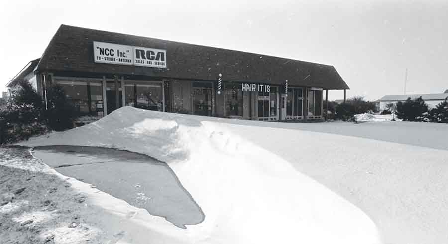
Photo: Christmas Record Snowstorm, 1989 - Drew Wilson Photographs, OBHC
FIRES
Luckily the Outer Banks has not had a lot of huge wildfires. Most of the fires we see are controlled burns by land conservation organizations. But one wildfire, the Pains Bay Fire of 2011, was particularly menacing. Occurring in Alligator River National Wildlife Refuge, the fire was caused by a lightning strike and burned more than 45,000 acres over nearly three weeks. For weeks, smoke from the fire affected air quality on the Outer Banks and made it difficult to breathe. The smoke and ash was so thick it blotted out the sun at times, and a layer of ash was left on vehicles and surfaces. Firefighters from U.S. Fish and Wildlife, the National Park Service, the N.C. Forest Service and many local municipalities worked to contain the fire until a dousing rain from Hurricane Irene finally put the fire out.
GHOST FORESTS
In eastern North Carolina near the Outer Banks you can witness the eerie ecosystem known as a ghost forest. In these areas, instead of healthy green trees, large swaths of pine and cypress trees have died, shed their bark and stand as tall, pale, ghostlike statues. The dead trees can stand for up to a decade before they topple.
Ghost forests, which are directly attributed to climate change and sea level rise, are expanding rapidly in eastern North Carolina – so much so they can be seen from space. Alligator River National Wildlife Refuge (ARNWR) on the Dare County mainland, has lost 11 percent of its trees since 1985 and is a prime place to see examples of ghost forest. Ride along U.S. Highway 264 toward Stumpy Point, and you can’t miss them.
Researchers attribute ghost forests to droughts, hurricanes, the presence of drainage canals, saltwater intrusion and sea level rise. Trees in ARNWR saw a large die off in 2011 following a drought and then a direct hit by Hurricane Irene, both of which made the ecosystem much saltier than ever before. Researchers say to expect the appearance of a lot more ghost forest in eastern North Carolina.
AURORA BOREALIS
Here we can claim spectacular sunrises and sunsets almost every single day. It’s commonplace to rush toward the water to see the big orange ball rising from the ocean or sinking into the sound, unobstructed by mountains, trees or buildings. Many days the glow of the sun on the clouds is spectacular and surreal, painting the sky in vivid oranges and reds or soft pastel pinks, purples and salmons.
But a sky painted by Aurora Borealis? We had never seen that until October 10, 2024. On this night, a geomagnetic storm triggered Northern Lights all across the United States, including the Outer Banks. Around 7:30 p.m. the skies turned a surreal pink and purple that lasted until the early morning hours. Aurora Borealis is the result of large bursts of energy from the sun that travel through space and enter the earth’s atmosphere at high latitudes where the magnetic field is weakest.
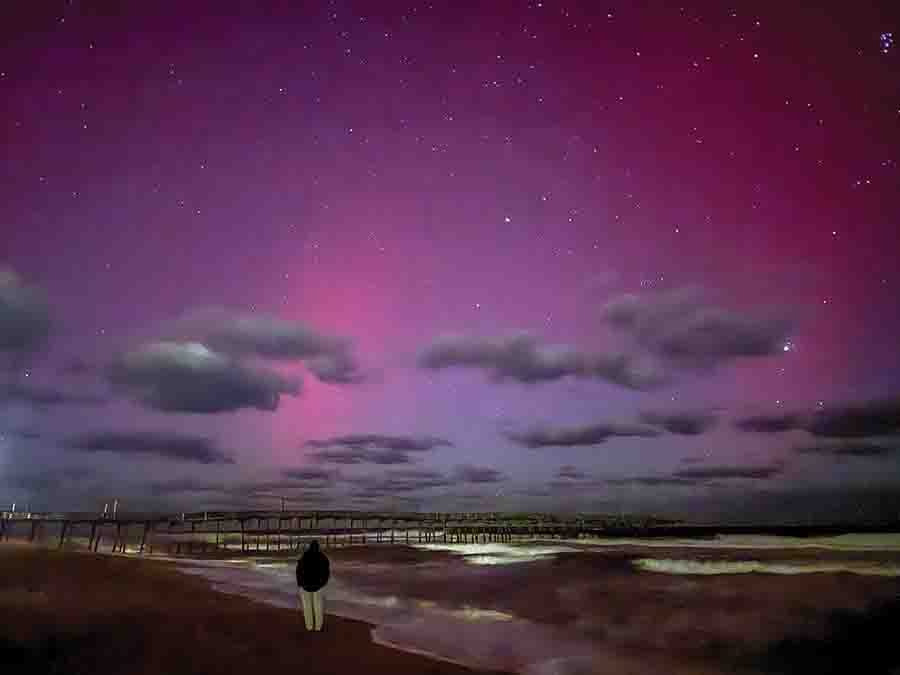
Photo: Aurora Borealis visible on the Outer Banks in 2024, Epic Shutter Photography
SENECA GUNS
On the Outer Banks it is not unusual to hear a single extremely loud, earthshaking boom seemingly out of nowhere. The boom is louder and more resonating than a thunderclap, and it will scare the bejesus out of you, even if you’re used to them. We colloquially call them sonic booms, but their official name is Seneca guns.
Seneca guns have been recorded routinely in eastern North Carolina and South Carolina and other locations like New York’s Lake Seneca and Lake Cayuga, coastal India (where they’re called Barisal guns) and the Netherlands, where they’re called mistpouffers.
Though they have an official name, no one is really certain what causes them or why they are isolated to particular geographic regions. But some scientists chalk them up to mini earthquakes.
The U.S. Geological Survey says this: “There have been many reports of booms that cannot be explained by man-made sources. Some of those booms are associated with a variety of interesting natural phenomena, including earthquakes.… Those on the East Coast have not been directly studied and explained, but we can deduce from observations and measurements in West Coast locations that at least some of the East Coast booms are associated with very small earthquakes. Small shallow earthquakes sometimes produce rumbling sounds or booms that can be heard by people who are very close to them. High-frequency vibrations from the shallow earthquake generate the booming sound; when earthquakes are deeper, those vibrations never reach the surface. Sometimes the earthquakes create booming sounds even when no vibrations are felt.”
Many of the photos in this story are courtesy of Outer Banks History Center (OBHC), State Archives of North Carolina.
About the Author Molly Harrison
 Molly Harrison is managing editor at OneBoat, publisher of OuterBanksThisWeek.com. She moved to Nags Head in 1994 and since then has made her living writing articles and creating publications about the people, places and culture of the Outer Banks.