
When my children were young, their favorite babysitter, a generational Wanchese native, always said goodbye the same way: “See you next week, God willin’ and the creek don’t rise.”
It’s a common saying among Outer Banks oldtimers because there’s some truth in it.
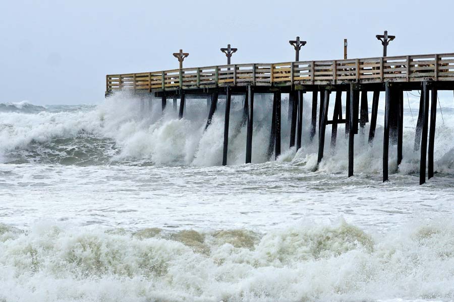
Very often, the creek does rise. The ocean washes over Highway 12. Northwest blows push sound water into places where it doesn’t belong. Fog settles over Oregon Inlet, thunderstorms materialize out of nowhere on summer afternoons and even a distant hurricane churns up ocean swell and dangerous rip currents.
Life on a chain of barrier islands surrounded by the Atlantic Ocean and wide sounds makes paying attention to weather, wind, tides and water a necessity, not only in storm situations, but also in everyday life.
Around here, everyone is always watching the weather. Watermen, fishermen, ferry workers, pilots, construction crews, pool cleaners, lifeguards, outdoor guides, surfers, kiteboarders, birdwatchers, beachgoers, cyclists, teachers, parents – everyone.
If our plans could possibly be affected by the weather, anywhere from 10 minutes to 10 days out, we have NASA-quality information right at our fingertips. Radar, satellites, computer models, hourly forecasts, wind predictions, tide charts – enough data to launch a spacecraft, decide when to go to the beach or at least secure the trash can lids before a blow.
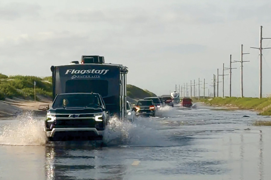
Above Photo Credit: Jenni Koontz/Epic Shutter Photography
In centuries past, Outer Bankers had simpler ways of predicting the weather. They looked toward the sky, listened to the ocean and watched the animals around them. Those creek rises came as a bit more of a surprise.
“We had lots of bad weather at times,” Ocracoke native Helena Parsons told historian Philip Howard about growing up on the island in the early 20th century. “Hurricanes, we called them storms in those days, we had no electricity, no TV or radio to give out the weather. The older people went by the stars, the clouds, the roar of the ocean.
“In September…clouds built up over the ocean, what the old folks called ‘double headers’ that they kept an eye on during storm season. The ocean would roar day and night when a storm was making up. My uncle was afraid of those clouds and would never leave in his boat.”
Like farmers and fishermen everywhere, Outer Bankers inherited generations of weather lore: “Red sky at night, sailors delight. Red sky at morning, sailors take warning;” “When seabirds fly to land there truly is a storm at hand;” “Mackerel sky, mackerel sky – never long wet and never long dry” And the ever-useful “Hark! I hear the asses bray. We will have some rain today.”
Fortunately, weather forecasting has come a very long way. And the Outer Banks played a role in getting us here.
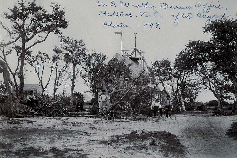
U.S. Weather Bureau Office, Hatteras Island, NC after August storm, 1899. Photo Credit: The Outer Banks History Center, Manteo, NC
The Weather Bureau Comes to the Outer Banks
Weather observation with instruments began in the late 1700s, and systematic weather observation in the United States began to expand in the 1800s, though getting the word out was a slow process. The invention of the electric telegraph in 1847 transformed forecasting because weather observations could be shared quickly across great distances.
In 1870 Congress authorized the creation of a national weather service under the U.S. Army Signal Service. Observers around the country collected information and telegraphed it to Washington, D.C., where forecasts – then called “probabilities” – could be developed and distributed.
The Outer Banks, jutting far into the Atlantic and notorious for storms and shipwrecks, quickly became an important part of the growing network. A coastal weather station was established at Cape Hatteras in 1874. Smaller observation stations followed at Kitty Hawk in 1875 (which moved to Manteo in 1904), Portsmouth and Cape Lookout in 1876 and Wash Woods, north of present-day Corolla, in 1878.
In 1891 all U.S. weather facilities were transferred into the Department of Agriculture and became known as the U.S. Weather Bureau.
The Hatteras weather operation moved several times before the U.S. Weather Bureau constructed a substantial new station in Hatteras Village.
“Cape Hatteras was an important location for weather forecasting where the Gulf Stream and Labrador Current meet,” NPS Historian Doug Stover wrote in a resource study about the Hatteras weather station. “The Weather Bureau felt that having a main station on the North Carolina coast was important enough to maintain a station in Hatteras Village.”
Built in 1901 and commissioned in 1902, the building included living quarters for the observer and his family, an office and observation room and a signal tower where weather and warning flags could be raised.
Observers at the stations recorded temperature, atmospheric pressure, wind speed and direction, visibility and humidity. Later, balloons were lofted into the atmosphere to collect information at higher elevations. Data was transmitted to the central Weather Bureau hub in Washington, D.C.
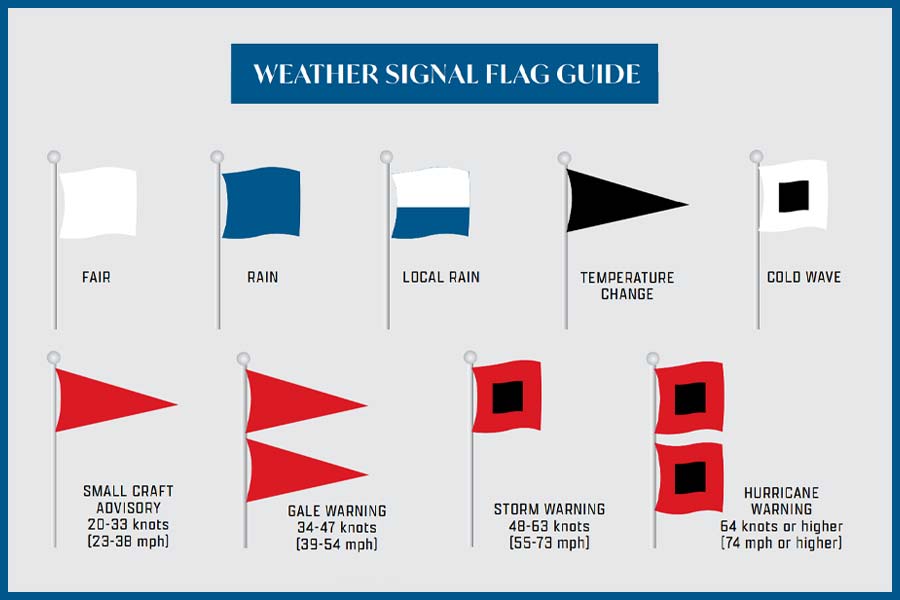
In coastal areas, one of the most visible innovations was much simpler: flags and signal towers. Weather signal towers allowed people to look up and know what might be coming. Different combinations of flags indicated wind direction, storms and other conditions, while lights communicated warnings at night.
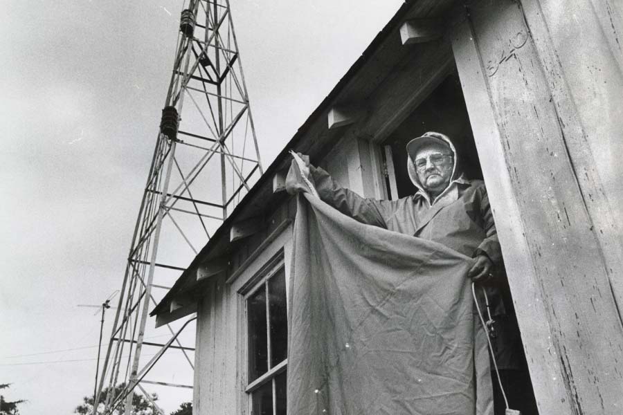
Old Weather Station at Hatteras and Storm Flags. Photo Credit: The Outer Banks History Center, Manteo, NC
In communities without telegraph service, weather warnings traveled the old-fashioned way – by word of mouth, sometimes from the mailboat. It’s been told that in the early to mid-1900s, residents of remote Portsmouth village got their weather reports dropped in on the island by airplane.
Government forecasting wasn't immediately embraced by everyone.
A 1914 inspector's report from Hatteras noted that the station was “tolerated within the community but not fully accepted,” adding that locals seemed to appreciate its ability to communicate with the outside world via telegraph more than its forecasts.
That attitude apparently changed.
Lucy Stowe, born in 1925 and later employed at the station, remembered villagers paying close attention to the towers.
“Absolutely they used them. You could see the top of the tower from all over the village, and the fishermen definitely paid attention to them.”
From the Outer Banks to the World
The history of Outer Banks weather observation intersects with a famous chapter of world history: the Wright brothers.
When Wilbur Wright was searching for a place to conduct flying experiments in 1900, he wrote to the U.S. Weather Bureau station at Kitty Hawk asking about conditions. Weather Bureau observer Joseph J. Dosher responded with information about the area's steady winds, open sand hills, communications and isolation, and the Weather Bureau's historic wind records convinced the Wright brothers to come to Kitty Hawk.
When they succeeded in making the world’s first flights on December 17, 1903, Weather Bureau communications helped spread the news. Orville went to the Kitty Hawk Weather Bureau office and sent the famous telegram home announcing their four successful flights.
At almost the same time, another technological revolution was unfolding on the Outer Banks.
Inventor Reginald Fessenden came to North Carolina under contract with the U.S. Weather Bureau to experiment with wireless communications. He established operations in Manteo and Cape Hatteras and in 1902 transmitted wireless telegraphy by tones across roughly 50 miles of open water between Buxton and Roanoke Island. The technology represented an enormous communications advancement, which would lead to receiving observations and distributing warnings without relying on telegraph wires.
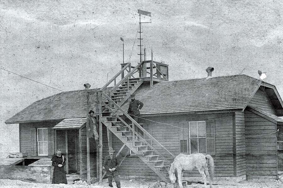
Mr. & Mrs. Dosher, possibly Oliver Neal Twiford on steps at Kitty Hawk Weather Bureau, 1898. Photo Credit: The Outer Banks History Center, Manteo, NC, Carol Cronk Cole Collection
Links to the Weather Bureau Era
Tangible links to the Weather Bureau era exist on the Outer Banks today.
One is a Weather Bureau record on display at the Graveyard of the Atlantic Museum in Hatteras village. The record states that at 11:25 p.m. on the night of April 14, 1912, the station received a wireless distress transmission from the Titanic: “CQD … Have struck an iceberg. We are badly damaged….”
Hatteras is the only known station in the United States to have received this first distress call from the Titanic. What happened from there, whether the Hatteras observer passed the information on to a higher office, is unknown. The record of the Titanic’s transmission was lost for nearly 100 years and was discovered rolled up in a wall as insulation during restoration work at the Hatteras Weather Bureau station in the early 2000s.
The Hatteras Weather Bureau station, which operated from 1902 to 1946, still stands in Hatteras village and is now an Outer Banks Welcome Center operated by the Outer Banks Visitors Bureau. The Weather Bureau functions were transferred to another location in Hatteras and then to Buxton in 1957. The building passed through many hands, and the National Park Service fully restored it to its historic appearance between 2001 and 2005. Visitors can see Weather Bureau memorabilia in the Welcome Center.
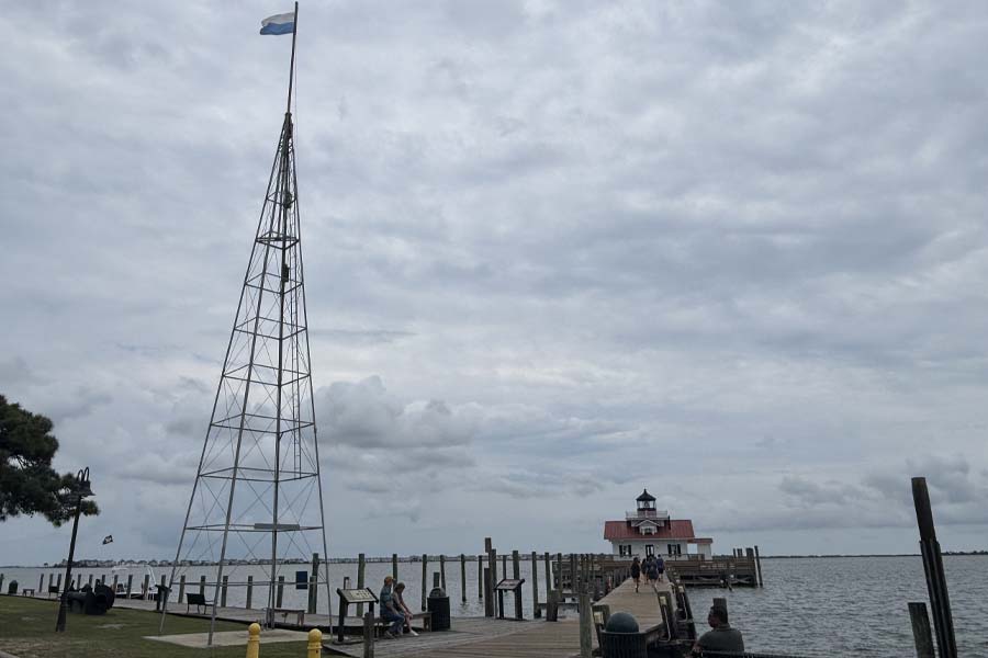
Another is the storm-warning tower on the Manteo waterfront. The tower dates to 1904, when the Weather Bureau moved its Kitty Hawk office to Manteo and established its warning system there. Local telegrapher and weather observer Alpheus Drinkwater tended the signals, flying flags by day and changing lights by night to alert residents to weather conditions. The tower moved several times before eventually standing at Drinkwater's home for decades. The Town of Manteo obtained it in 2005, refurbished it and put it back on the waterfront, where the flags continue to change according to weather reports. To this day, at least some Manteo residents keep a copy of the flag signal meanings near a window overlooking the flag pole.
Today's surf warning flags on the beach are similar to the early weather signal flags. Lifeguards fly easily recognizable colored flags to warn about ocean conditions: yellow for moderate hazard of rip currents, single red for high hazard and double red for highly dangerous conditions (swimming prohibited).
Reading the Weather
Even as forecasting became more sophisticated, people who made their living or recreated on the water had their own ways of watching the local weather.
Longtime Outer Banks surfer Lynn Shell, owner of Outer Banks Boarding Company, remembers when finding waves required a working knowledge of meteorology.
“In my early days of surfing, we had to learn how to read the weather and a weather map,” Shell says. “How to track low-pressure systems, how to read isobars, how tight and strong the winds would be and how far out they were. We knew low pressure is going to be counterclockwise winds and form bigger waves and high pressure systems clockwise with less power in the swell.”
In the late 1970s, Shell and his friends would visit the weather station in Buxton looking for information.
“The man at the station would share info with us,” he says. “He liked that we were interested. We would interpret it and share it.”
A good surf day required knowledge, patience and some detective work.
“In the old days there were no surf cams,” Shell says. “You had to go out and find a good sandbar. And there was no way to tell anyone what you found. The only way anyone could see where you were surfing was to ride by and see your car on the road.”
Fishermen had their own weather networks.
Captain Brian Horsley of Outer Banks Fly Fishing remembers the days when captains at Oregon Inlet Fishing Center relied heavily on one another.
“When the weather was bad, the captains at the fishing center would get out on the porch and talk,” Horsley says. “We listened to the older captains like Omie Tillett and Billy Baum. We trusted their experience. Omie wouldn’t say anything he didn’t believe.”
Once, early in Horsley's career, thick fog settled over the area.
“Omie said the fog would be gone by 10:30, but I had a trip and I left anyway,” Horsley recalls. “We got fogged in awful, waiting for the fog to lift. And it was gone by 10:30. I should’ve listened.”
Horsley also remembers calling friends to interpret the weather.
“I had a friend who was a Coast Guard radio operator and could read a weather map really well,” Horsley says. “I’d get info from him and pass the word around. We really leaned on our fellow captains.”
They still do.
“We still talk about what it’s going to do,” Horsley says. “Technology is useful. If I’m home, I’m looking at the weather and texting people who I know are fishing. We all look out for each other.”
Radar in Your Pocket
The Weather Bureau became the National Weather Service in 1976. Today there is no National Weather Service station on the Outer Banks, ironically because Cape Hatteras was too close to hurricanes and coastal storms for the late 1970s-era radar operation. Official forecasts and warnings for the region are issued by the National Weather Service office, part of the National Oceanic and Atmospheric Administration (NOAA), in Newport/Morehead City.
Doppler radar became a cornerstone of the National Weather Service's modernization beginning in the 1980s, and the weather-observation network has greatly expanded from there. Satellites watch weather systems from space. Radar tracks precipitation and storms. Weather balloons gather atmospheric information. Offshore buoys monitor conditions at sea. Computer models process massive amounts of atmospheric, oceanic and land data to make predictions.
For tropical systems, the National Hurricane Center works with local National Weather Service offices to develop forecasts, watches and warnings. Storm-surge watches and warnings, added in 2017, are particularly important for low-lying coastal communities like the Outer Banks.
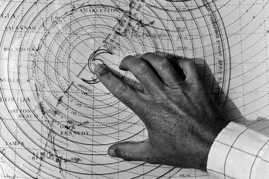
Decision Arcs system map for hurricane plotting for Dare County, 8-8-1988. Photo Credit: The Outer Banks History Center, Manteo, NC, Drew Wilson Photographs
Some of the information about local conditions is being collected right here.
The Coastal Studies Institute maintains a meteorological station on a platform in Croatan Sound near the ECU Outer Banks Campus. It measures wind speed, air and water temperature, atmospheric pressure and water level. CSI also operates three waverider buoys off the Outer Banks in partnership with the Coastal Data Information Program at Scripps Institution of Oceanography. One sits about 8 miles southeast of Oregon Inlet and another about 10 miles offshore of Nags Head. They measure wave height, speed and direction as well as sea-surface temperature.
Today, surfers have access to ubiquitous surf cams. Surfline and other webcam networks offer live views from dozens of locations up and down the Outer Banks (and coastlines all over the world). Before driving anywhere, surfers can live-check the waves from their bed. And friends can easily meet up thanks to location tracking..
It’s easy to feel nostalgic for the old days, Shell says. “It was a lot more adventurous then. I don’t even want to go there about what the iPhone has done to surfing. It’s taken the adventure out of it.”
Yet Shell acknowledges how the advancements have improved the sport, safety, predictions and visitation to the Outer Banks.
Horsley appreciates the technology.
“I prefer that radar in my pocket,” Horsley says. “I’ve been caught in bad storms – don’t like lightning. It makes life easier.”
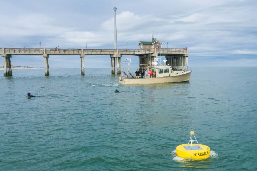
Photo Credit: Coastal Studies Institute
What's Next?
The future of weather forecasting promises even more information and forecasting abilities. NOAA’s website points to an AI-driven future, touting “a groundbreaking suite of artificial intelligence (AI)-driven global weather prediction models, marking a significant advancement in forecast speed, efficiency and accuracy.”
“NOAA’s strategic application of AI is a significant leap forward in American weather model innovation,” said Neil Jacobs, Ph.D., NOAA administrator, in a press release. “These AI models reflect a new paradigm for NOAA in providing improved accuracy for large-scale weather and tropical tracks, and faster delivery of forecast products to meteorologists and the public at a lower cost through drastically reduced computational expenses.”
For the Outer Banks, those advances will make a difference. Knowing that a hurricane is offshore is one thing. Knowing where the greatest storm-surge threat may occur, how winds will affect sound water, where ocean overwash is likely or when dangerous conditions could arrive gives residents, visitors, emergency managers and watermen much more useful information.
Yet despite all the technology available to us, Outer Bankers will still do what they have always done: Gather up in yards, coffee shops, beach accesses and docks or get on the phone and yak endlessly about what the weather’s going to do.
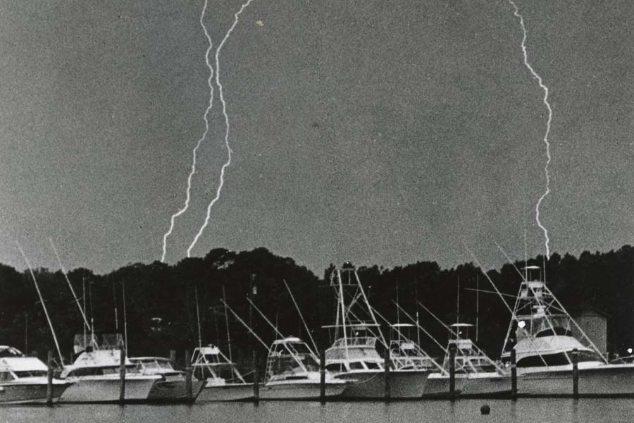
Lightning crashes behind trees behind Salty Dawg Marina, Roanoke Island, 1988. Photo Credit: The Outer Banks History Center, Manteo, NC
Weather Proverbs and Wives Tales
Red sky at night, sailors delight. Red sky at morning, sailors take warning.
When seabirds fly to land there truly is a storm at hand.
Mackerel sky, mackerel sky – never long wet and never long dry.
March comes in like a lion and goes out like a lamb.
If the clouds move against the wind, rain will follow.
When deer are in gray coat in October, expect a severe winter.
Much noise made by rats and mice indicates rain.
Anvil-shaped clouds are likely followed by a gale of wind.
If rain falls during an east wind, it will continue a full day.
Northeast blows last for odd days – one, three, five, seven or nine.
Sharks move to deeper water just before hurricane landfall.
If there is thunder in winter, it will snow within seven days.
Cows with tails held upright is a sign of an approaching storm
If birds fly low, expect rain and a blow.
About the Author Molly Harrison
 Molly Harrison is managing editor at OneBoat, publisher of OuterBanksThisWeek.com. She moved to Nags Head in 1994 and since then has made her living writing articles and creating publications about the people, places and culture of the Outer Banks.